Anstey
An Introduction to Anstey (local copy)
Anstey Maps
Open Street Map: Anstey, Hertfordshire
Map Finder: Anstey, Hertfordshire, with Outlines - National Library of Scotland
Ordnance Survey: Hertfordshire IX (includes: Anstey; Langley; Meesden; Nuthampstead ... Surveyed: 1876 to 1878, Published: 1880 to 1883 - National Library of Scotland
Anstey in Domesday Book
Anstey was a settlement in Domesday Book, in the hundred of Edwinstree and the county of Hertfordshire.
It had a recorded population of 35 households in 1086, putting it in the largest 20% of settlements recorded in Domesday, and is listed under 2 owners in Domesday Book.
Land of Count Eustace (of Boulogne), Tenant-in-chief in 1086
This landowner is associated with 0 places before the Conquest; 136 after the Conquest. (Note that the same name is not necessarily the same person.)
Prior to this assignment, the land was under: Overlord in 1066: Earl Harold / Lord in 1066 Alward (the noble).
The original folios of Domesday Book, a complete survey of England [was] written in AD 1086.
Anstey in the hundred of Edwinstree in Victoria County History - Hertfordshire, A History of the County of Hertford: Volume 4, pg 11 ff (@ Internet Archive)
Anstey (hertfordshire-genealogy.co.uk)
Anstey Church | St George, Anstey, Hertfordshire
The church at Anstey is really something special, and should be better known, not just in the county but the whole of England.
'Henry Ginne in 1539 made a bequest to St. Stephen's gild in this church'. (VCH, vol 1, p 17)
Anstey Conservation Area Appraisal And Management Plan Draft For Consultation 2018 (PDF) (eastherts.gov.uk)
3.5. The Domesday Book was a census commissioned by William I in 1086. In relation to Anstey it advises The Count (Eustace Count of Bologne?) himself holds Anstey. It is assessed at 5 hides. There is land for 120 ploughs. In demesne 5 Hides...There 8 villans with a priest and 6 bordars have 5 ploughs…There are 5 cottars and 6 slaves, meadow for half a plough, pasture for the livestock woodland for 50 pigs. In all it is and was worth £14. Also in Anstey Payne holds half a hide of Hardwin. There is land for 11/2 ploughs…with 4 bordars and 4 cottars and 1 slave. Meadow for 1/2 a plough, pasture for the liveslock, woodland for 12 pigs. This land is worth 20s, when received 10s. 3.6. Interpretation: A ‘Hide’ was a standard unit of land measurement interpreted to be about 120 acres. A ‘villan’ [villein] was a peasant legally tied to land he worked on and of higher economic status than a 'bordar '. A cottar is a tenant occupying a cottage in return for services. 'Demesne’ essentially means land belonging to the lord of the manor. (pg 7-8)
6.1. Anstey is a linear village with a number of high quality listed buildings, one particularly important Scheduled Ancient Monument illustrates its rich historical heritage. The latter spans the 900 years or so from the Norman Conquest right through to the present day where modern stained glass in the church commemorates USAF servicemen who died in the Second World War, stationed nearby. There are a number of non listed buildings worthy of the additional protection afforded by conservation area status. (pg 35)
Anstey Fair
Once a year, on the nearest Sunday to St. Swithun's Day, the village holds its Fair. The Fair is the highlight of the community's year and is held on the nearest Sunday to St. Swithun's Day. The money raised goes to support the Church,the school and other causes around the village. The Fair first started in the Middle Ages and was held on Cheapside. This is how Cheapside got its name. The Fair was restarted in 1978 by the Reverand Roger Tamplin. At the Fair you can play games, buy things, eat and drink, win prizes, see exhibitions and have a good time. In 1984 the Fair raised £1,755.
source: D-block GB-540000-231000 (BBC - Domesday Reloaded [ARCHIVED CONTENT (1986)] Anstey Fair, Local history)
Anstey, Hertfordshire (Official site): History (Anstey Soldiers Who Fell in World War I)
ANSTEY, a parish, in the union of Buntingford, hundred of Edwinstree, county of Hertford, 4 miles (N. E.) from Buntingford; containing 497 inhabitants. It is situated on the road to Cambridge through Barkway, and comprises 2051a. 3r. 11p. A fair is held on July 15th. The living is a rectory, valued in the king's books at £21. 13. 4.; net income, £504; patrons, the Master and Fellows of Christ's College, Cambridge. Corn-rents were assigned to the rector under a private act in 1826, as a commutation in lieu of tithes. The church is a cruciform edifice, with a central tower surmounted by a short spire supported by Saxon arches, and is said to have been built from the ruins of a castle erected by Eustace, Earl of Boulogne, soon after the Conquest, traces of which are still visible. (Topographical Dictionaries A Topographical Dictionary of England, pp58-62)
Anstey, Hertfordshire, Wikipedia
Anstey in Edwinstree Hundred: Parish in the County of Hertfordshire: Survey of English Place-Names
A county-by-county guide to the linguistic origins of England’s place-names – a project of the English Place-Name Society, founded 1923.
Anstey Parish Council
Anstey Parish Council strives to make Anstey a better place to live, work and play. Our website includes a wealth of information about how we conduct business and what we do.
The Hundred Parishes: An introduction to ANSTEY
Location: 4 miles northeast of Buntingford. Ordnance Survey grid square: TL4032. Postcode: SG9 0BY.
Access: off B1368. Bus: 20 Anstey - Bishops Stortford (Mon-Sat, 3 times a day).
County: Hertfordshire. District: East Herts. Population: 299 in 2011.
A small, peaceful and secluded village whose name was derived from “hean stige“, Anglo-Saxon for ’high pathway’. A castle was built here on this high ground soon after the Conquest but was demolished in the reign of Henry III. Stone from the castle was used in the building of the present church, St George’s, which stands adjacent to the castle mound and replaced the original Saxon building. The mound with its surrounding moat can still be seen and was the site in October 1944 of the tragic crash of an American B- 17 bomber less than a mile from its base at Nuthampstead airfield. Fragments of wreckage are still recovered from time to time. Perhaps the only fortunate thing about that awful event was that the church was undamaged. It is an impressive and unusual building being cruciform in shape and dates from the 12th century. The church is noted for its abundance of early graffiti, some dating as far back as the 13th century. A careful tour of the building will reveal helmets, shields, scallops (the symbol of pilgrims), wagons and merchants, and even a three legged pot incised into the walls and pillars.
The 11th-century font is one of only two known to be decorated with the figures of Mermen (the other is in St Peter’s in Cambridge). Mermen were mythological creatures, the male counterparts to mermaids.
The close bond that was formed in WWII between the village and the men of the U.S. 398th Bomb Group is commemorated in the Millennium window in the church on which is recorded the names of all those from the unit who died.
Another unusual feature of St George’s is the lychgate which dates to the 15th century. In 1831 the left hand side was bricked up and a stout studded door set into it for use as the village lock-up. It was still being used as such as recently as 1920.
Also worthy of inspection is what is known as the village well (seen below) although some experts have suggested that the mechanism with its large iron wheel was more likely a well head.
The village pub, the Blind Fiddler, takes its name from the enduring legend of George the Blind Fiddler of Anstey. It was said that a tunnel ran from Cave Gate, a pit west of the village to the castle mound about a mile away. For a bet, George entered it with his dog and playing his fiddle. Suddenly a horrific scream was heard and the dog emerged singed from head to tail. George was never seen again!
Today, the pub provides a focal point for village social life and sustenance to cyclists and walkers who enjoy the parish’s quiet lanes and footpaths, including the long-distance Hertfordshire Way.
Hospitality: The Blind Fiddler – SG9 0BW - 01763 848000
Adjacent parishes: Hormead, Wyddial, Barkway, Nuthampstead, Meesden, Brent Pelham.
source: http://www.hundredparishes.org.uk/FreshFiles/PDFs/ANSTEY.pdf.
Anstey, Hertfordshire: UK Genealogy Archives - genealogy heraldry and history
Anstey, Hertfordshire genealogy site with description, census transcripts, parish records, and many other resources.
"ANSTEY, a parish, in the union of Buntingford, hundred of Edwinstree, county of Hertford, 4 miles (N. E.) from Buntingford; containing 497 inhabitants. It is situated on the road to Cambridge through Barkway, and comprises 2051a. 3r. 11p. A fair is held on July 15th. The living is a rectory, valued in the king's books at £21. 13. 4.; net income, £504; patrons, the Master and Fellows of Christ's College, Cambridge. Corn-rents were assigned to the rector under a private act in 1826, as a commutation in lieu of tithes. The church is a cruciform edifice, with a central tower surmounted by a short spire supported by Saxon arches, and is said to have been built from the ruins of a castle erected by Eustace, Earl of Boulogne, soon after the Conquest, traces of which are still visible".
Transcribed from A Topographical Dictionary of England, by Samuel Lewis, seventh edition, published 1858.
Anstey Wildlife.
The best places to observe wildlife are Scales Park and Northey Wood. The moat is a good place for water and waterside creatures. The best time to observe wildlife is at dawn. Large mammals found in the area are foxes,deers and badgers. The tiny muntjac deer is common in the area. Squirrels,hedgehogs and many smaller mammals are abundant. The farms support hundreds of rats that feed on the wheat grain. The chalky soil in the area supports cowslips and orchids among the many wild flowers. The orchids like wet chalky soil and so grow in the woods. There is much insect life supporting the larger creatures. Tortoise shell, Peacock,small white, Brimstone and Orange Tip butterflies are all common in the area.
source: D-block GB-540000-231000 (BBC - Domesday Reloaded [ARCHIVED CONTENT (1986)] Anstey Wildlife, Local history)
Tithe map of Aston (parish), Hertfordshire.
Tithe map of Aston (parish), Hertfordshire. Shows buildings, named open fields, boundary posts, glebe, field gates, plantations, woods, waste land, heath/moor, footpath and/or bridleway, waterbodies. Colouring used. Scale: 1 inch to 3 chains. Note that this map is a copy of an original map by Mallam.
With 1 altered apportionment map, dated 1858, at 2 inches to 6 chains. Other altered apportionment maps are located with the apportionment.
This is available to download from TheGenealogist ($$)
History of Anstey in East Hertfordshire: : A Vision of Britain Through Time, University of Portsmouth
A vision of Britain from 1801 to now. Including maps, statistical trends and historical descriptions.
In 1870-72, John Marius Wilson's Imperial Gazetteer of England and Wales described Anstey like this:
"ANSTEY, a parish in Royston district, Herts; on Ermine-street, near the river Quin, 3½ miles NE of Buntingford, and 6½ SSE of Royston r. station. Post town, Buntingford. Acres, 2,170. Real property, -£3,194. Pop., 473. Houses, 93. A castle stood here upon a high round hill, said to have been erected, soon after the Conquest, by Eustace, Earl of Boulogne; but was demolished, in the time of Henry III., "because it had been a nest of rebels." The moat which surrouuded it, and some works which were added in the time of King John, still remain". ... and ...
"And on this side Anestie, which was not long since the inheritance of the house of Yorke, and in elder times the Castle there was a nest of rebels, wherefore Nicolaus of Anesty, Lord thereof, was expresly commanded by King Henry the Third to demolish so much of it as was raised since the Barons wars against his father King John. But now time hath wholy rased it all". (William Camden: Buckinghamshire, Bedfordshire and Hertfordshire)
Pete's Walks - The Hertfordshire Chain Walk
"Anstey was one of the most interesting villages that I have passed through on the Hertfordshire Way".
The Area Around Anstey.
The Area Around Anstey. Anstey, Meesden and Brent Pelham are small villages in the Hertfordshire countryside.There are only a few hundred people in each. The land around is almost entirely farmland,with small copses and woods. There is one large stretch of woodland called Scales Park. The farmland is mainly arable with some dairy, pig and chicken farming. Most of the people work outside the villages, travelling to nearby towns or into London and all but a few children are bussed to nearby town schools. It is a quiet area with few recreational facilities although many fund raising functions are held throughout the year. Many of the people have chosen to live in the area because of the quiet.There are some historical sites such as the castle mound,the church and many moats.
source: D-block GB-540000-231000 (BBC - Domesday Reloaded [ARCHIVED CONTENT (1986)] The Area Around Anstey, Local history)
Public Houses, Inns & Taverns of Anstey (PubWiki)
- The Blind Fiddler Pub formerly known as: Chequers, Anstey, Buntingford, Hertfordshire
The Blind Fiddler of Anstey (The Legend)
One of many villages to the north-east of Buntingford, Anstey was evidently significant enough in mediaeval times to have had a castle. It also produced the curious legend of Blind George the fiddler and the Devil’s Hole.
The Complete Anstey Story – From 1143 to Modern Times (Anstey family name) (archive.org)
The patriarch of the medieval Ansteys (and indeed almost all Ansteys alive today) is Hubert de Anstey (archive.org), the first holder and originator of the Anstey surname. Hubert was not born an Anstey, but he became an Anstey during his mid-adulthood, passed his ‘Anstey’ surname onto his children and died an Anstey. We can pinpoint to the year the moment that Hubert’s surname (and therefore also the surname ‘Anstey’) first came into existence ex nihilo, that year being 1143.
Hubert married Agnes de Sackville c1125, and they had two sons, Richard de Anstey and John de Anstey (who head the two major medieval Anstey sub-branches) and a daughter, Maud. A lot is known about Hubert’s life, including the fact that he was Chamberlain to Matilda of Boulogne, wife of King Stephen of England – however by far the most important aspect of his life concerns the events that brought about the birth of our Anstey surname in 1143.
The Domesday Survey (quickgen.net)
The Domesday survey is a comprehensive record of the extent, value, ownership, and liabilities of land in England, made in 1086 by order of William the Conquerer. The survey was carried out, against great popular resentment by seven or eight panels of commissioners, each working in a separate group of counties, for which they compiled elaborate accounts of the estates of the king and of his tenants in chief (those who held their land by direct services to him). From these documents the king’s clerks compiled a summary, which is Domesday Book.
- Continental Origins of English Landowners Database (COEL) by Dr. Keats-Rohan
- The Prosopography of Anglo-Saxon England (PASE)
The Prosopography of Anglo-Saxon England is a database which aims to provide structured information relating to all the recorded inhabitants of England from the late sixth to the late eleventh century. It is based on a systematic examination of the available written sources for the period, including chronicles, saints’ Lives, charters, libri vitae, inscriptions, Domesday Book and coins; and is intended to serve as a research tool suitable for a wide range of users with an interest in this period.
Trumpington Local History Group, Anstey Hall Farm, Archaeology, Open Day, 10 May 2015
There was an open day at the archaeological excavation at Anstey Hall
Farm on Sunday 10 May 2015, with visitors having an opportunity to hear
about progress on site. Groups were shown around by Richard Mortimer
and Stuart Ladd, Oxford Archaeology East, and we are very grateful to
them and their volunteers for a fascinating afternoon. Visit report by
Andrew Roberts. One of a number of pages about local archaeology.
An Inventory of the Historical Monuments in Hertfordshire: Historical Introduction, RCHME Inventory Volumes, British History Online
"The two most important of the lesser castles were Benington and Anstey. Benington had been the head of a Saxon Lordship which was held before the Conquest by the thegn Æthelmær. William I. granted it to Peter de Valognes, and it became the head of the Valognes barony in Hertfordshire. Roger de Valognes was apparently a partisan of Geoffrey de Mandeville and was present with him at Stephen's celebrated Easter Court in 1136. On the Pipe Roll for 1177 is a charge for 100 picks for throwing down the keep (turrim) of Benington, which points to the keep having been at that time of stone, for, had it been of wood, it would probably have been burnt, and picks would have been unnecessary for its demolition. The stump of a small 12th-century keep still remains
Anstey Castle is a formidable stronghold. The great mount with its deep ditches still filled with water is perhaps the finest example of a 'motte' in the county. Unfortunately its early history has not been traced. At the time of Domesday, Count Eustace of Boulogne held Anstey in his own hands, and tradition has it that he built the castle. By the end of the 12th century it was held by a family bearing the name of Anstey. In 1218 Nicholas de Anstey was given till mid-Lent to throw down the castle so that nothing should remain of it except that which was built before the Barons' war. (fn. 15) What was destroyed may have been the masonry keep, indication of which apparently came to light during some excavations made in 1903 by Mr. R. T. Andrews and Mr. W. B. Gerish. In 1225 the castle was in the King's hands and the custody of it was given to the Archbishop of Canterbury. (fn. 16) Dionisia, daughter and heir of Nicholas de Anstey, married William de Munchensy and their daughter and heir Dionisia married Hugh de Vere."
Anstey is in the Edwinstree Hundred (Hertfordshire Genealogy) | Maps
 Hertfordshire hundreds |
 Similar map with parish names (Click for full size) |
Anstey | MAP (ARCHI UK)
ARCHI the Historical Search Hound has found 731 local archaeological and historic sites and ancient monuments within 10 km of your search area Anstey, Hertfordshire (TL4032 / TL 40 32). Archaeological Site Data from British Archaeological Records, Historic Sites and Monuments Databases, Local History Sources and Archaeology Research Reports.
Anstey (GENUKI)
Historic England search: 41 records found for 'Anstey Hertfordshire'
Anstey Walk # 132: A walk of great variety, 6.9 miles, Anstey, Barkway and Nuthampstead
Aston
Aston Parish Council (archive.org)
See: Footpaths in Aston (archive.org)
Aston Maps
Open Street Map: Anstey, Hertfordshire
Map Finder: Aston, Hertfordshire, with Outlines - National Library of Scotland
Ordnance Survey: Aston, Hertfordshire XXI (includes: Benington; Little Munden; Sacombe; W... Surveyed: 1878 to 1880, Published: 1884 (Eastern part) - National Library of Scotland
Aston in Domesday Book
Aston was a settlement in Domesday Book, in the hundred of Broadwater and the county of Hertfordshire. It had a recorded population of 27 households in 1086, putting it in the largest 40% of settlements recorded in Domesday.
Land of Bishop Odo of Bayeux
Households
Households: 11 villagers. 5 smallholders. 6 cottagers. 4 slaves. 1 priest.
Land and resources
Ploughland: 15 ploughlands. 4 lord's plough teams. 1 lord's plough teams possible. 5 men's plough teams.
Other resources: 4.0 lord's lands. Meadow 2 ploughs. Woodland 200 pigs.
Valuation
Annual value to lord: 18 pounds in 1086; 14 pounds when acquired by the 1086 owner; 20 pounds in 1066.
Owners
Tenant-in-chief in 1086: Bishop Odo of Bayeux.
Lord in 1086: Bishop Odo of Bayeux.
Bishop Odo of Bayeux
This landowner is associated with 0 places before the Conquest; 575 after the Conquest. (Note that the same name is not necessarily the same person.)
After the Conquest
Tenant-in-chief in 1086:
Tenants-in-chief held land directly from the Crown.
Lord in 1086:
The immediate lord over the peasants after the Conquest, who paid tax to the tenant-in-chief.
(The lord had been changed as a consequence of the conquest of England by William the Conquerer; formerly was :
Overlord in 1066: Archbishop Stigand under Edward the Confessor.
Odo of Bayeux (died 1097), Earl of Kent and Bishop of Bayeux, was the maternal half-brother of William the Conqueror, and was, for a time, second in power after the King of England. (source: https://en.wikipedia.org/wiki/Odo_of_Bayeux)
"The Bishop [of Bayeux] himself holds ESTONE [Aston]. It is assessed at 10 hides." (VCH, vol. 1, pg 365)
Aston, Hertfordshire: History of Aston in East Hertfordshire: A Vision of Britain Through Time, University of Portsmouth
"In 1870-72, John Marius Wilson's Imperial Gazetteer of England and Wales described Aston like this:
ASTON, a parish in the district and county of Hertford; on the river Beane, 3 miles SE of Stevenage, and 4 SE by S of Stevenage r. station. Post Town, Stevenage. Acres, 2,052. Real property, £3,697. Pop., 639. Houses, 122. The manor belonged to the Saxon kings; was given, by the queen of Henry I., to Reading abbey; and passed, at the dissolution, to the Botelers of Walton. ... The manor-house, at Aston Place, is a building of older date than the time of Henry VIII. Six large barrows, supposed to be Danish, occur contiguous to the public road. The living is a rectory in the diocese of Rochester. Value, £380.* Patron, the Rev. G. A. Oddie. "
Aston, Hertfordshire (hertfordshire-genealogy.co.uk)
Aston, Hertfordshire, Wikipedia
ASTON VILLAGE @ASTON Herts Local History by Des Turner; original written in 1990, updated in 2019. (local copy (txt))
Historic England search: 56 records found for 'Aston Hertfordshire'
Aston in Broadwater Hundred: Parish in the County of Hertfordshire: Survey of English Place-Names
A county-by-county guide to the linguistic origins of England’s place-names – a project of the English Place-Name Society, founded 1923.
Parish: Aston in the hundred of Odsey in Victoria County History - Hertfordshire, A History of the County of Hertford: Volume 3, pp54-58 (British History Online)
The parish of Aston has an acreage of 2,070 acres, of which 1,007¾ are arable land, 648¾ acres permanent grass and 122¼ acres wood.
Public Houses, Inns & Taverns of Aston, Stevenage, Hertfordshire (PubWiki)
Hertfordshire

HERTFORDSHIRE is an inland county of an extremely irregular form, and its boundaries are of the like character. Its most distant extremities lie in a direction nearly north east and south-west; its shortest, south-east and north-west. Upon the north it is bounded, for a few miles, by the county of Cambridge, and its north-eastern angle also meets the latter county; for a considerable distance it is bounded on the east by Essex, and its southern boundary is formed (with some palpable indentions) by Middlesex; upon the western side are the counties of Bucks and Bedford - the latter county likewise extending to, and meeting Cambridgeshire on the north. Some difficulty exists in ascertaining with precision the dimensions of Hertfordshire: measured, however, from Royston, upon its N.N.E. confines, to the extremity of its most southerly indenture with Bucks, its length is about thirty-six miles; and its greatest breadth, taken in an oblique direction, from Bishops Stortford on the east, to Berkhampstead, upon the confines of Buckinghamshire, on the south-west, is about thirty miles: but its medium length may be grossly estimated at thirty miles, and its breadth at twenty-five miles. Its ambit is calculated at somewhat between one hundred and thirty and one hundred and forty miles, and the government returns state the area to comprise 528 square miles or 337,920 statute acres. In size it ranks as the thirty fifth county in England, and in population as the thirty-fourth.
SOIL, and CLIMATE, PRODUCE and MANUFACTURES. - The SOILS of this county mix and run into each other in a very remarkable manner, so that they cannot be traced and named with any great certainty: the prevailing ones are loam and clay; the former is met with in almost all its gradations, and is more or less intermingled with flints, or sand. The vales through which the rivers or brooks take their course are composed of a rich sandy loam, with the exception of a small quantity of peat, or marshy moor. The principal clay district is on the north-east or Essex side; yet even here the upper surface is in general a strong wet loam. The only parts where the soils may be considered sterile are in the parishes of North Holt and North Mims, and the lower part of that of Hatfield; but these, of late years, have been much improved under the management of the agriculturist. The chalky soil prevails generally on the northern side of the county; but indeed the basis of the whole county is chalk, either more or less pure, though the depths at which it is found vary. The CLIMATE of Hertfordshire is considered as most salubrious; and the air is generally mild; to delicate constitutions its temperature has been pronounced soothing and efficacious. These advantages, with the general beauty of the country, the goodness of the roads, and the almost uninterrupted fertility of the soil, have been the means of making this county a favourite residence, and inducing great numbers of wealthy persons to purchase lands for building villas - thereby causing estates to multiply in a manner unknown in the distant counties. The general aspect of Hertfordshire is extremely pleasant; and though its eminences are not enough elevated, nor its vales sufficiently depressed and broken, to claim a decisive character of picturesque or romantic beauty, yet its surface is so diversified as to constitute a considerable degree of fine scenery.
PRODUCE. - By far the greatest proportion of Hertfordshire is under tillage; - as a corn county, it is considered as one of the first in England: the produce in wheat, barley and oats is very considerable; large quantities of turnips are also grown and artificial grasses cultivated to a very great extent. The meadows are very productive in many parts, and the various streams which intersect the land are extremely favourable to irrigation. In the south-west corner of the county are many orchards; apples and cherries are their principal produce, which always finds a ready market in London. The quantity of waste lands is but inconsiderable; many acres of these are appropriated as sheep down. As the land in this county is chiefly arable, live stock has become an object of very inferior regard: the Suffolk breed is considered the best; the sheep are mostly ewes of the South Down and Wiltshire kinds. The horses are of various kinds, but the Suffolk breed appears to have the preference. The chief MANUFACTURES of Hertfordshire, at one time, were cotton and silk; the former has much declined, nor is the latter carried on extensively. When the article was more worn than of late years, Berkhampstead employed many female hands in making black lace; but the principal employment of the labouring females, in most parts of the county, is platting straw for hats, bonnets, &c. A very considerable quantity of malt is made in various places; and there are also many flour mills and lime kilns. Paper is manufactured in several towns.
(extract from: Pigot & Co, British Atlas, Counties of England, 1831; found at: https://www.mtholyoke.edu/courses/rschwart/hist256/pigot/sthmidl.htm#HTF)
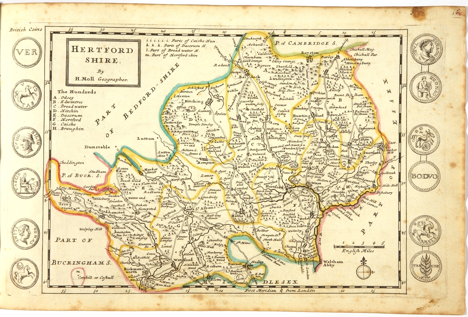
Hertfordshire Map by Herman Moll (c.1724) (Click for full view)
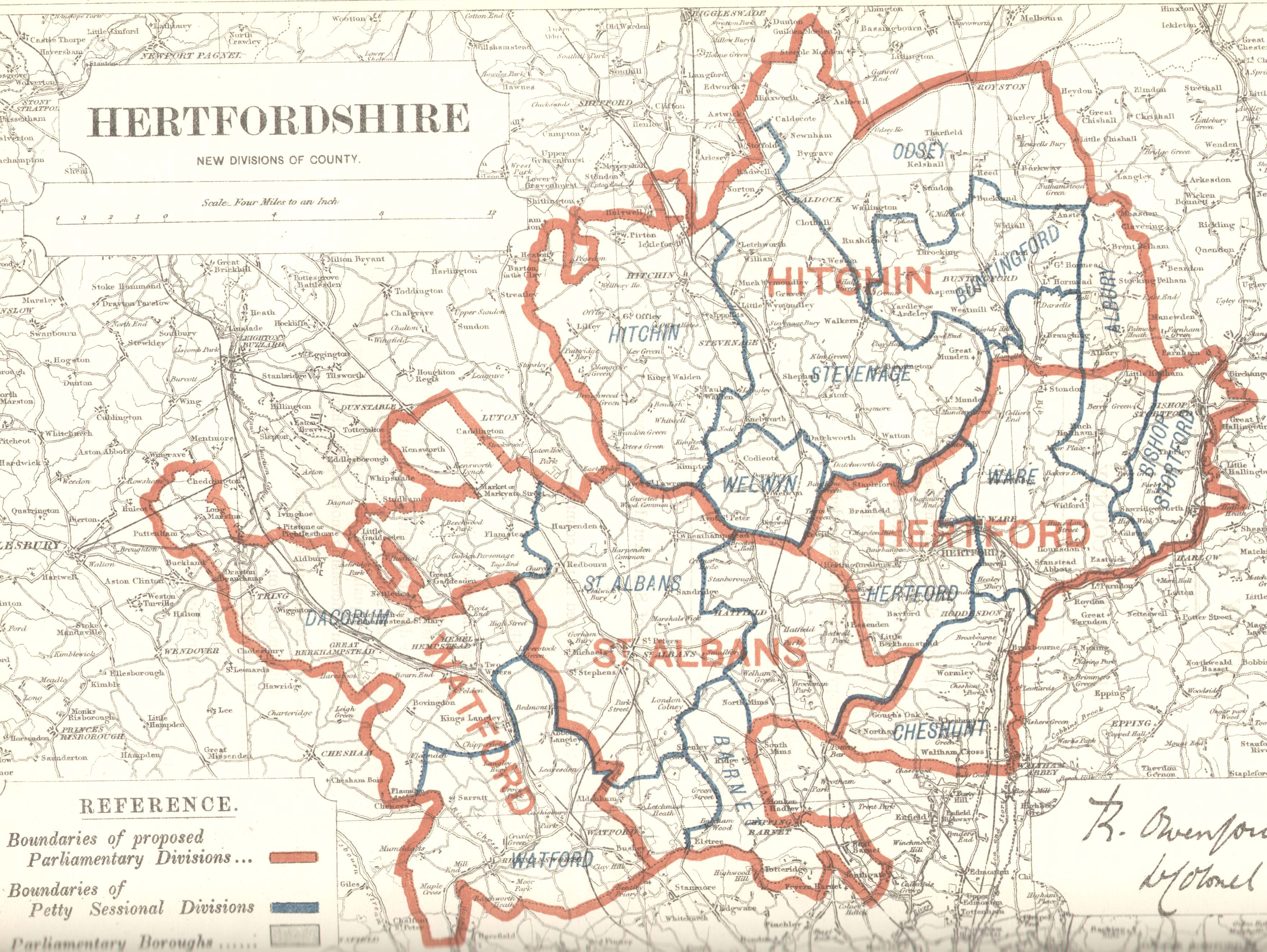
Hertfordshire after re-division in 1885: Anstey is now in Buntingford and Aston is now in Stevenage. List of Hertfordshire boundary changes (Wikipedia)
County-Wise Map of Hertfordshire
Hertfordshire by Richard Lydekker, Cambridge County Geographies, 1909
Hertfordshire by Herbert W Tompkins, First Published March 1903; Second Edition, Revised 1922
"Anstey (about 4½ miles N.E. from Buntingford Station, G.E.R.) has a cruciform church of mixed styles: the nave is Dec., the transepts [Pg 51]E.E., the S. porch Perp. The tower rests upon four Norman arches; the font also is Norman. The church was restored in 1871; many features of architectural interest being wisely retained. The recumbent effigy in the recess in S. transept is thought to be that of Richard de Anestie, who founded the church in the fourteenth century. We learn from Domesday Book that at the time of the Great Survey there was “pannage” (i.e. acorn woods) at Anestie sufficient to feed fifty hogs, and that the manor was worth fourteen pounds a year. There was once a castle here, built soon after the Conquest, the site of which is supposed to be marked by the remains of a moat still to be traced in the grounds of Anstey Hall. The churchyard is entered by a covered lich-gate".
History of Hertfordshire (Wikipedia)
History of Hertfordshire (Wikiwand)
1349: The Black Death comes to Hertfordshire by Michael Long, Hertfordshire Life, 2019
Spring of 1349 in Hertfordshire came with a black cloud - a plague that would wipe out as much as half the population. It brought death but also major social change. The beginning of the pestilence was in 1350 minus one ... only the wretched of the population live to tell the tale.
"From death, despair and chaos, however, emerged a new England. When the pandemic finally passed, the economic balance in the county had changed, and the seeds of wider social transformation were sown. Survivors found they had more economic power in their hands, as there were too few workers to farm the land: crops rotted in fields for want of labour to harvest them. Where previously peasants had been tied to their village and the local lord, unable to move without permission, now circumstances meant they could demand higher wages and seek work elsewhere.
It certainly brought dramatic changes in employment, society and land ownership as the shortage of workers contributed to the collapse of the feudal system across England. A wealthier class of peasant emerged, who, in time, would become the gentry".
Plague and Isolation in St Albans c.1600, The power of the Black Death of the late 1340s and the 1665 Great Plague of London to evoke horror continues long after we have left school. Rightly so when we recall that the former killed something like 50 per cent of the population of England. But as there were outbreaks of contagious disease every 20 years or so in the late 16th and early 17th centuries, this focus blinds us to the experience of our predecessors in St Albans some 400 years ago. Just how significant were these outbreaks and what were their effects?
The power of the Black Death of the late 1340s and the 1665 Great Plague of London to evoke horror continues long after we have left school. Rightly so when we recall that the former killed something like 50 per cent of the population of England. But as there were outbreaks of contagious disease every 20 years or so in the late 16th and early 17th centuries, this focus blinds us to the experience of our predecessors in St Albans some 400 years ago. Just how significant were these outbreaks and what were their effects?
The Herts Genealogist and Antiquary by William Brigg, B.A., Harpenden, Hertfordshire, England, 1895-1899 (wikitree.com)
The Hundred Parishes Society: Parish List (all in PDF format)
The villages of North Hertfordshire by Keith Fitzpatrick-Matthews
"We use the term ‘held’ rather than ‘owned’ because in feudal law, everything belonged either to the king or to the church, so lords of the manor only had properties because their feudal overlords had granted it to them. The could throw out the lord at any time they wanted".
- Settlements in North Hertfordshire (PDF) (Local copy) Note: Anstey and Aston are not in the list.
The Origins of Hertfordshire by Tom Williamson, 2000 - Google Books
The Lost Landscape of Stevenage by Lee Prosser, @ Stevenage Town Council
The Victoria history of the county of Hertford by William Page, 4 volumes (Medieval Genealogy)
- The Victoria history of the county of Hertford, Volume 1 by William Page, 1914 (TXT) @ Internet Archive | also @ Wikisource
'Domesday Survey', starts at page 315
'The landholders of Hertfordshire', starts at pg 357 - A History of the County of Hertford: Volume 2 (British History Online)
This volume covers the south and west of the county and includes areas, such as Barnet and Elstree, that are now within greater London. It also includes a detailed account of the city and cathedral of St Albans. - A History of the County of Hertford: Volume 3 (British History Online) (Volume 3 (TXT) @ Internet Archive)
Covers the northern and eastern parts of the county, including accounts of Baldock, Bishop's Stortford, Hitchin and Letchworth, as well as the county town of Hertford. - A History of the County of Hertford: Volume 4
A part-volume describing the religious houses of the county, including the Abbey of St Albans. (pp 365-467)
Volume 4 @ Internet Archive
Index of places mentioned in the titles of articles in the published volumes of the Victoria County History for Hertfordshire
Therfield, Hertfordshire Genealogy
Therfield is a village and scattered parish, upon the chalk range, extending to the Cambridge border, 3 miles south from Ashwell station on the Hitchin and Cambridge line of the Great Northern railway, 3 miles south-west from Royston and 8 east-by-south from Baldock, and in the Northern Division of the county, Odsey hundred and petty sessional division, Royston union and county court district, rural deanery of Baldock and archdeaconry and diocese of St Albans. Principal landed proprietors ... include ... Francis John Fordham esq. of Royston.
The soil is mixed, heavy and light: subsoil, chalk and clay. The chief crops are wheat, barley, beans and some roots. The area is 4,704 acres; rateable value, £3,005; the population in 1011 was 681 in the civil and 579 in the ecclesiastical parish.
Bandons (Historic England)
Located very near to Anstey Village. Centre of manor formed in C15 from Anstey Manor. A manor house of outstanding interest for its unusually large and elaborate timber framed parlour cross-wing.
An Introduction to Wyddial (local copy)
Wyddial, Hertfordshire Genealogy
WYDDIAL (or WIDIALL) is a parish in Edwinstree hundred, Buntingford Union, Royston county court district, rural deanery of Buntingford and archdeaconry and diocese of St Albans. The village, which is small and inconsiderable, is 1½ miles north-east of Buntingford, which town is partly within the parish and 7½ south from Royston. The church of St Giles is an ancient structure, consisting of chancel, nave and north aisle, south porch and a western embattled tower, with spire, containing 4 bells, the first dated 1866 and the tenor 1666, the second has an invocatory inscription to St Katherine and the third is undated; in 1867 Mrs Ellis caused all the bells to be re-hung and gave the clock in the tower: there are several stained windows, including two in the aisle apparently by a Dutch or Flemish artist of the 17th century and some monuments and brasses to the Gulston, Gyll and Ellis families; in the north wall of the chancel is a brass with effigy and inscription to Dame Margaret, daughter and heir of Sir Thomas Nevyll kt. brother to Lord Abergavenny and wife of Sir Robert Southwell kt. Master of the Rolls, who died 1575; there are also brasses of the Gyll family 1535-1600. The register of baptisms dates from 1666; burials from 1669. The living is a rectory, yearly value £326, with residence, in the gift of the trustees of Charles Heaton Ellis esq. and held by the Rev Charles Maxwell B.A. of Balliol College, Oxford. Wyddial Park is a considerable domain close to the village belonging to Heaton Ellis, who is lord of the manor. The principal landowners are the trustees of Chas. Heaton Ellis, William Butt esq. and Kings College, Cambridge. The chief crops are wheat and barley. The area is 1,187 acres, rateable value £1,904; and the population in 1881 was 202.
Wyddiall Hall, a domain of 180 acres close to the village, is the seat of Lieut.-Col. Charles Henry Brabazon Heaton-Ellis D.L., J.P. who is lord of the manor. [Kelly 1917] He was still there in 1933.
The parish of Wyddial contains 1,542 acres. (History of hertfordshire, v4)
"Wyddial Hall, N. of the church, is a two-storeyed building of plastered brick; the roof is tiled. The house is of 18th-century design, but incorporates the shell of a late mediæval building, of which little detail remains. The cellars are built of early 16th-century brick, and have niches with inverted V-shaped heads, and windows of three lights with defaced stone mullions, possibly original. Some of the timbers of the roof appear to be mediæval material re-used, and some early 17th-century panelling remains. ... arms and inscription: in the floor, of John Gille, 1546, and his wife, eight daughters, arms and inscription, indent of sons: to George Gyll, 1568, and his two wives, inscription and broken shield with arms: to John Gill, 1600, and Joan his wife, inscription and arms: in the N. chapel, to Helen (Gulston), wife of John Joscelyne, 1640, arms and inscription: indent of civilian, lower part of figure brass, with indent of inscription said to be of George Canon, 1534: brass inscription (now kept at the Rectory) to George Canon, recording that he built the aisle in 1532, died 1534" ( 'Wyddial', in An Inventory of the Historical Monuments in Hertfordshire (London, 1910), pp. 244-245. British History Online [accessed 28 April 2021]. )
The block consists of Wyddial village and most of Wyddial parish plus a western section of Anstey parish and a southern section of Barkway parish. It is a rural area. Three-quarters of it is open fields which are cultivated for cereal crops and oil-seed rape. It has gentle, undulating landscape dotted with trees and small woods. The river Quin drains the eastern side to the south. Wyddial village is small, having only thirty-three houses. These included Home Farm and Wyddial Bury Farm which are still working farms. The map also shows six outlying farms. Only Biggin Manor remains as a working farm, the land attached to the others having been absorbed into larger units. There are seventeen other houses scattered over the area in small groups. Most people work outside the area.
source: D-block GB-536000-231000 (BBC - Domesday Reloaded [ARCHIVED CONTENT (1986)] Wyddial, Local history)
Entries re: Wyddial Hall and Bandons are relevant to John Ginn of Anstey d. 1694 who married Mary Gill. At the time of this marriage, the seat of this branch of the Gill family was at Wyddial Hall but they also owned Bandons.
Notes about farming in northeastern Hertfordshire
As Pigot says: "PRODUCE. - By far the greatest proportion of Hertfordshire is under tillage; - as a corn county, it is considered as one of the first in England: the produce in wheat, barley and oats is very considerable; large quantities of turnips are also grown and artificial grasses cultivated to a very great extent".
"TABLE 79. Acreage under crops in 1866: Anstey: Wheat: 250.50 Barley: 283.00 Oats: 101.50 Rye: 10.00; Table 80: Aston: Wheat: 495.00 Barley: 464.50 Oats: 154.50
"TABLE 81.- -Agricultural Statistics: Parish Sunaries, 1866
Acreage under crops. Stevenage area.
Parish 1 2 3 4 5
Aston 2073 2514.20 1114.00 877.92 522.27
TABLE 82.- -Agricultural Statistics: Parish Sunaries, 1866
Acreage under crops. Buntingforda rea.
Parish 1 2 3 4 5
Anstey 2150 1451.13 645.00 522.75 283.38
Key to Columns
1 Parish acreage, 1801 Census
2 Estimated acreage, 1866.
3 Total cereal acreage.
4 Total grass acreage.
5 Total acreage under other crops.
source: Crompton Thesis, 1995
Brookfield Farm Butchery, Aston End Road, Aston, Stevenage, Hertfordshire SG2 7EU
Church Farm, Ardeley
"Ardeley Bury, all the land and farms around it and three other villages were given by the first King of England – Athelstan – in around 900AD to the Canons of St Pauls Cathedral in London. They owned it for the next 1000 years – the wealth from here went to maintenance of the Canons and the Cathedral." (History page)
Ardeley Bury is about 3 miles northeast of Aston.
Meet the farmers, May 9, 2012; Updated: February 3, 2021, Hertfordshire Life
North Herts Farmers - Hertfordshires Farm Buying Group
Thrift Farm, Royston: Law Farming
Law Farming covers more than 1800 ha on the Hertfordshire, Cambridgeshire, and Essex borders and we are based at Thrift Farm in Royston
Brick House Farm: Planning – Application Map
3/20/1089/ARPN | Conversion of a single agricultural barn to 1 x 1 bedroom and 1 x 2 bedroom residential units. | Lower Farmyard Brick House Farm Brick House Lane Great Hormead Buntingford Hertfordshire SG9 0PB
Farmhouse at Lord's Farm, Aston; (17th C) (Historic England)
Was: W.A Moss, Lords Farm, Long Lane, Aston End, Stevenage, SG2 7HD Tel 01438 880247
Farmhouse at Oaks Cross Farm, Aston; (16th C) (Historic England)
Farmhouse At Poplar Farm, Long Lane, Aston End, Stevenage (Historic England)
"Poplars: During the planning stages of the Poplars in the late 1970s, it was known as the Aston End Brook area. It was probably named after Poplar Farm, in Long Lane just north of the area. The farm has been owned by the Clark family for several generations, and is now an equestrian centre." (ourstevenage.org.uk)
Foxholes Farm, Hertford, Hertfordshire
The Foxholes family farming partnership began just after the Second World War, started by Catherine’s grandfather, Alfred Ronald Smith, then followed by his sons and now, along with Catherine’s father and cousin, they continue to farm in excess of 1,000 acres of arable land near Ware, Hertfordshire, growing crops for bread, oil, animal feed and bedding.
Great Domesday
Great Domesday covers the English counties not included in Little Domesday (Essex, Norfolk and Suffolk) with some exceptions. It does not include the cities of London and Winchester, nor Bristol and Tamworth. Coverage of the north west of England is limited. The counties of Durham and Northumberland are omitted, and coverage of Cumberland, Westmorland and north Lancashire is confined to lands of the King and the fiefsglossary icon of two others. Coverage of south Lancashire is limited. It includes some border areas which are now Wales but at the time were in Anglo-Norman hands.
Little Domesday
Little Domesday is the first draft or ‘circuit summary’ covering the counties of Essex, Norfolk and Suffolk. Because the information from Little Domesday was never entered into Great Domesday, Little Domesday was kept as the final record for East Anglia.
World of Domesday > Life in towns and villages
The villages were comparatively undeveloped. Many were still little more than scattered hamlets, not yet settled into the nucleated pattern of the medieval village. However, some settlements like Isham, Northamptonshire, had been replanned by the lord and peasants, with a green and a church in the centre, surrounded by houses, with arable land combined into two or three large open fields.
Life for the Domesday peasant was harsh. Peasant houses were made of wood, wattle and mud and needed frequent rebuilding. People shared a single large room with their animals for warmth in winter, and cooking was over an open fire. Clothes were made of wool, flax and animals skins. Only the elite, the lord, the priest and the reeve – the lord’s steward – and perhaps some of the wealthier peasants enjoyed superior housing and clothes and more to eat.

Village lives revolved around the agricultural calendar. In spring the animals grazed in the pasture, and seed was sown. Summer was the busiest time, particularly when the harvests of wheat, barley, rye, hay, vegetables and fruit were being gathered. In autumn the animals grazed on the remains of the crops, providing manure for the fields, which were then ploughed. Winter was the time when family and those animals not killed for meat stayed indoors.
source: World of Domesday > Life in towns and villages
World of Domesday > The social order